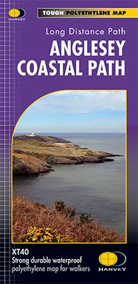
Carte de randonnée - Anglesey Coastal Path XT40 | Harvey Maps - National Trail maps carte pliée Harvey Maps

Carte de randonnée - Anglesey Coastal Path XT40 | Harvey Maps - National Trail maps

Carte de randonnée - Anglesey Coastal Path XT40 | Harvey Maps - National Trail maps

Prix régulier 22,95 €
/
  • Expédition sous 24 h ouvrées depuis notre entrepôt en France
  • Frais de livraison calculés instantanément dans le panier
  • Retours gratuits (*)
  • Stocks en temps réel
  • 1 en stock
  • En rupture de stock, expédition prochainement
Taxes incluses.
Carte de randonnée éditée par Harvey Maps idéale pour découvrir les sentiers nationaux de Grande Bretagne.
Description originale de l'éditeur :

Entire route on one map
The 200km (125 mile) long Anglesey Coastal Path is a long distance route that follows much of the island's coastline and comprises one section of the Wales Coast Path. The path primarily caters for walkers however, cyclists and horse riders can also enjoy certain sections.

The path falls within a designated Area of Outstanding Natural Beauty which covers 95% of the coast. It passes through landscape that includes a mixture of farmland, coastal heath, dunes, salt-marsh, foreshore, cliffs and a few small pockets of woodland.

Tough, light, durable and 100% waterproof
Includes Rights of Way
Route clearly marked


ISBN/EAN : 9781851375851
Date de publication : 2016
Echelle : 1 / 40 000 (1 cm = 400 m)
Impression : recto
Dimensions plié(e) : 11,6 x 24,3 cm
Dimensions déplié(e) : 69,6 x 97,2 cm
Langue(s) : anglais
Poids : 70 g

Customer Reviews

No reviews yet
0%
(0)
0%
(0)
0%
(0)
0%
(0)
0%
(0)